


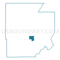
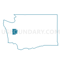
Airport Voting District, Mason County, Washington
About
Outline

Summary
| Unique Area Identifier | 687569 |
| Name | Airport Voting District |
| County | Mason County |
| State | Washington |
| Area (square miles) | 7.60 |
| Land Area (square miles) | 7.43 |
| Water Area (square miles) | 0.17 |
| % of Land Area | 97.72 |
| % of Water Area | 2.28 |
| Latitude of the Internal Point | 47.26694160 |
| Longtitude of the Internal Point | -123.13144680 |
Maps

Graphs
Select a template below for downloading or customizing gragh for Airport Voting District, Mason County, Washington


Neighbors
Neighoring Voting District (by Name) Neighboring Voting District on the Map
- Bayshore Voting District, Mason County, WA
- Capitol Hill Voting District, Mason County, WA
- Eells Voting District, Mason County, WA
- Mountain View Voting District, Mason County, WA
- Northside Voting District, Mason County, WA
- Shelton 16 Voting District, Mason County, WA
- Union Voting District, Mason County, WA
Top 10 Neighboring County Subdivision (by Population) Neighboring County Subdivision on the Map
- Shelton CCD, Mason County, WA (20,843)
- Union-Grapeview CCD, Mason County, WA (13,303)
- West Mason CCD, Mason County, WA (6,467)
Top 10 Neighboring Place (by Population) Neighboring Place on the Map
Top 10 Neighboring Unified School District (by Population) Neighboring Unified School District on the Map
Top 10 Neighboring State Legislative District Lower Chamber (by Population) Neighboring State Legislative District Lower Chamber on the Map
Top 10 Neighboring State Legislative District Upper Chamber (by Population) Neighboring State Legislative District Upper Chamber on the Map
Top 10 Neighboring 111th Congressional District (by Population) Neighboring 111th Congressional District on the Map
Top 10 Neighboring Census Tract (by Population) Neighboring Census Tract on the Map
- Census Tract 9602, Mason County, WA (5,743)
- Census Tract 9606, Mason County, WA (5,429)
- Census Tract 9605, Mason County, WA (4,888)